The Daily American from West Frankfort, Illinois • Page 26
- Publication:
- The Daily Americani
- Location:
- West Frankfort, Illinois
- Issue Date:
- Page:
- 26
Extracted Article Text (OCR)
lorgesf MM-Southm Illinois Ifeiila 4 VOLUME XL Swvlng Hit GtogfopMc. Popntotteti and Trodt Cwirer of fa mporfailf Southtrn Illinois Industrial Area WEST FRANKFORT, ILLINOIS FpT RELATE TALE OF QUADROON GIRL'S PLIGHT Master of Halfway House Purchased Her From Cherokee Owners to Be freed No slory of the Shawneetown-St. I road would bo complete without the romantic tale of Priscilla the Quadroon girl and the Halfway House, the historically famous stopping place for travelers of the early 1800 's near what is now known as Mulkeytown. Karly settlers of the area now included in Franklin county's Tyrone township wore the Mulkeys, Barzillia a Levi Silkwood, George Tcferteller, William Tinsley, John Kirkpalrick anil Benjamin N. Harrison.
It is probable that Mulkeytown was named after the Mulkey family, though 13aiv.il- lia Silkwood and his Halfway House are famous to Franklin county history. Silkwood, whose first name was often shortened to plain Basil, came to Franklin county in 1822 where he carved out his homestead on the lonely stretch of wilderness road running between what are now the towns of West Frankfort and Tamaroa. His log stable was the first building on the road west of Moses Garrett's tavern, which was located just east of what is now West Frankfort on the blacktop road, then the Shawneetown Trail. The village of Mulkeytown sprouted nearby some 15 years after Silkwood erected his stable. After Silkwood's death the railroad replaced the stage route and still later 111.
Highawy 14 was built to carry the speeding traffic that replaced the travelers who were patrons of Halfway House. The paved highway between Benton and DuQuoin runs a quarter mile south of the old stage road. Oubln liullt First A log cabin with one large room was the tavern stopping-place Silkwood opened for travelers of the 1820's. Halfway House was so "KOtoed beoa stood midway on the road between St. Louis and Shawneetown.
Many of the immigrants who moved westward as new lands were opened up undoub- NUMBEB 17 tedly stopped at Halfway House. Their herds fed on the same pasture that Silkwood grazed his stock and the settlers took refreshment from Silkwood's tables. Silkwood also had other responsibilities. The Little Muddy river crossing near his tavern had been a stopping place on the mail route between Shawneetown and Kaskaskia since early territorial days. Residents of the area requested a post office in 1831 and the Silkwood tavern was designated the postof- fice because of its convenient location and importance as a meeting place for settlers and where news from the outside world was first reported.
Silkwood kept the postoffice for nearly 211 years, distributing mail from the bag made up at the Shawneetown office. That mail bag traveled a historic route by horseback, sulkey and then by stage coach. In later years the Little Muddy post- office, Silkwood's place of business, was moved to the village of Mulkeytown. The historic Halfway House, a two-story building, was erected in 1828, as evidenced by the date carved into a chimney stone. Silkwood Married Twice Barzillia Silkwood was married twice, according to early historians, to the sisters Mahalah and Mariah Dement.
Their brother, John Dement, was one of the heroes of the Black Hawk War and was elected treasurer of Illinois he- fore he left his home in "Egypt" for one in Dixon. John and David Dement were among the first settlers of Denning township and what is now known as the village of Plumfield was once called lament's settlement. Barzillia Silkwood was well- known for his generosity as is evidenced by the 40 acres of land lie is said to have given to each of 16 orphans he raised when they reached the age of marriage. Bitterly opposed to slavery, he was said to have once paid every gold piece in his possession, while on a trip away from home, for a Negro boy, John, whom he freed but kept at the Silkwood home until he reached the age of 21. I'riHcllla'H Plight From Silkwood's bitter opposition to slavery comes the story of Priscilla the Quadroon.
Silkwood made a business trip to Jonesboro in the winter of 1838 and there he found Priscilla, the slave owned by a wealthy member ot the Cherokee tribe of Indians which was then on its famed cross-country trait. Silkwood paid 51,000 in gold for Priscilla, buying her from her Cherokee master and taking her with him back to Halfway House. When CLARK MARCHED IN TUC "TDAII flF SOUTH ILLINOIS TO ME I lullL UT ATTACKKASKASK.A EGYPT STORY George Rogers Clark, the famed military expert of early America, was directed by the Virginia legislature on Jan. 2, 1778 to raise a force of soldiers and proceed along the inland waterways to capture the British fort at Kaskaskla, one Tacet of the Revolutionary War. Some historians claim that Clark beached his boats in mouth of a small stream which enters the Ohio river, near Fort Massac, and trekked overland across Southern Illinois to attack Kaskaskla.
His trail is said to have crossed Williamson ounty. Kaskaskla was captured on July 4, 1778. Illinois Central Was Chartered Jan. 1836 The Illinois Central railroad, an important factor in the development of Illinois and Egypt, was chartered by the state legislature on Jan. 18, 1836 freed by Silkwood, Priscilla chose to remain at Halfway House and was accepted as a member of the family to which she was devoted.
In the words of an earlier historian, it was said: "Priscilla was accepted as a respected member of the community and of the Mulkeytown Christian church. Silkwood 's will charged his executors with providing for the support of 'Priscilla, a colored She lived her full three score and ten and is buried near her Franklin county home." One trace of Priscilla may be found in "mallows," the dwarf type hollyhock with small red blooms found in many Southern Illinois gardens. Tradition says that Priscilla planted at Halfway House the seeds of the flowers that grew around the cabin in Carolina where she was born. When the plantation owner died and his property was sold at auction, Priscilla became the property of a wealthy Cherokee. She is said to have filled her apron pocket with flower seeds to carry away some memento of her home.
They bloomed for her in her Indian home and she again took the seeds with her when the Cherokees started their westward trek. They wejjward trek. Wbomedagam tn the yard oTHal waa-affned In and way House U. S. Savings Bonds today for that home of tomorrow.
Chtfoktts Crossed Area on Long Trok to Wost; Little Hospitality Was Shown The "Trail of Tears" is a tragic story, the Story of the trek of the "Treaty Cherokee" Indians of the Cherokee nation across 800 miles of the United States from their home in Tennessee, Alabama, North Carolina and Georgia to the vast prairie land west of the Mississippi river in Oklahoma. The "Trail of Tears" is tied closely to Southern Illinois history for the Cherokees moved across this land on their long trail westward. This is the time and the people from whom Barzillia Silkwood, master of the famed Halfway House, at what is now Mulkeytown, on the Shawneetown Trail, purchased the pretty quadroon slave girl, Prinscilla, who lives in Franklin county history. The story begins many years ago when there lived in East Tennessee and adjacent states the Cherokee nation, a tribe of Indians some 18,000 strong. They had lived for uncounted years at the southern end of the Smoky Mountain range where they had attain ed an advanced stage of civilization as measured by modern stan dards.
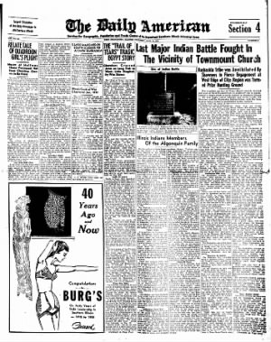
It is said that Georgia and the Cherokees never did get along too well together. In 1815, the Indians found gold on a small stream at the foothills of the Blue Ridge Mountains. They tried to keep the secret but it leaked out and by 1828 thousands of Indians and whites flocked to the diggings This gold find was said to have been the straw that broke the camel's back. The United States government, with Andrew Jackson as president, signed a treaty with a small group of the Cherokees which bound the whole nation to an agreement that they would move west. treaf Last Major Indian Battle Fought In The Vicinity of Townmount Churdh of Indian Battle Kaskaskia Tribe was Annihilated By Shawnees in Fierce Engagement at West Edge of City; Region was Termed Prize Hunting Ground I The roadside marker at Town Mount church, located just west of West Frankfort on 111.
Highway 149, is significant of a tragic event in early history of Southern Illinois the last major battle between two bitter rivals, the Shawnee and the Kaskaskia Indian tribes, with the Kas- kaskias being virtually annihilated in the conflict. History terms the valley of the A roadside marker, on 111. Highway 149, just west of West Frankfort, at the site of TUMI Mount church, marks the historic battleground of tJie last major conflict between the Kaskaskia and Shawnee Indians, fought in 1802. The Shawnees, a powerful tribe, were victorious. inois Indians Members Of the Algonquin Family Congratulations a a tO a a a BURG'S On Forty Years of tyle Leadership In Southern Illinois 1915 to 1955 kees were to vacate their' eastern lands by May 1838.
Loath To Leave Loath to leave their homeland, it is said the Cherokees had made no preparations to leave when General Winfield Scott and troops were sent into the area to enforce provisions of the treaty. Some of the Indians fled into the mountains and others voluntarily began the migration but the soldiers forced some 1,000 members of the tribe into each of 14 prison camps. Finally an agreement was reached whereby the United States would pay $600,000 for the traveling expenses of the imprisoned Cherokees in return for their assent to migration. The time of departure was set for Sept. 1, 1838.
A Baptist minister tells the details of the beginning of the tragic trek, of ilfe in the prison camps during the summer of 1838. He wrote on June 16, 1838: "The Cherokee are nearly all prisoners. They have been dragged from their homes and encamped at the forts and military posts all over the nation. In Georgia, especially, multitudes were allowed no time to take anything with them except the clothes they had on. Females who have been habituated to comforts and comparative affluence are driven on foot before the bayonets of brutal men.
Many of the Cherokee who a few days ago were in comfortable circumstances are now in abject poverty." Fourteen groups of the Cherokee were to travel separately, three days travel apart. Camp sites svere arranged for every 12 to 15 miles with provisions to be purchased along the way. The "trail" wound west from near Chattanooga through McMinnville, Murfreesboro, Nashville and Hopkinsville, to Golconda, 111. At Golconda the ferry was owned by John Berry. From Golconda, the main trail passed through the sites of Dixon Springs, Grantsburg, Vienna, West Vienna, Mt.
Pleasant, Anna, Jonesboro and Ware and finally crossed the Mississippi at Green's ferry and thence to Jackson, and west to Oklahoma. Winter Wiw Bitter The Cherokee crossed the 60 mile stretch of Southern Illinois, known as Egypt, in the bitter winter months under numerous hardships. Through the winter, the Indians trekking westward were strung from Tennessee into Kentucky and on through Illinois and Missouri. In nine of the groups, 424 deaths and 71 births were recorded during the march but the list is far from complete with no records available for several of the larger groups. Daniel S.
Butrick, a missionary sent to the Cherokee by the American board of Commissioners for Foreign Missions, joined a group headed by Richard Taylor, a man who held many offices of trust in the Cherokee nation. This group reached the Ohio river, across from Golconda, on Dec. 15. Butrick wrote: "As we are now passing out of a slave state (Kentucky) into a free, we are reflected on the pleasure of landing where (Continued on Page Five) The first settlers in Illinois found the only tenants to be Indians which belonged to that family grouping (on the basis of language) termed the Algonquins. The Illinois Indians were formed in a loose organization of six or more tribes known as the Illinois confederacy.
Tribal members of the confederacy were the Metch- igamis, the Kaskaskias, the Peor- ias, the Cahokias and the Taminar- were -the Fiankashaws, the Weas, the Kick- apoos and Shawnees and probably other tribes or remnants which lived on Illinois soil for longer or shorter periods of time. The Metehigainis lived along the Mississippi river, having originally come from west ot the "Father of Waters." They sojourned in the vicinity of Fort Chartres and were the objects of earnest missionary effort on the part of the Jesuits. They also lived in the vicinity of Lake Michigan, to which they gave their naniP, and were allies of Pontiac in his war of 176-1. They perished with other members of the confederacy at Starved Hock in 1769. The Kaskaskias originally lived on the upper reaches of the Illinois river and it was here that Marquette planted one of the first missions in Illinois.
They moved to the mouth of the Kaskaskia river about 1700,. founding there the first life at the ancient settlement of Kaskaskia, the first state capital of Illinois, which eventually became the center of French life in the interior of the continent. Tribes United It is said that the Tamarons and the Kaskaskias united into one tribe in the first part of the century under the leadership of their great chief, John Baptiste Du- Quoigne, who was a personal friend of General George Washington. Their numbers, greatly reduced from 1 the approximately 6,000 to 8,000 who resided in the vicinity of Kaskaskia from 1700 to 1800, were in constant friction with a branch of the Shawnees who lived east of the Big Muddy river in what is now Saline and Gallatin counties. These two remnant tribes and the Shawnees fought a bloody battle in 1302, near what is now the site of Townmount church, just west of West Frankfort.
The powerful Shawnees were too strong for the Kaskaskias who were forced westward to the Big Buddy where the slaughter continued until most of the Kaskaskias were either killed or captured. Tradition terms the heated engagement the "battle of Battle Creek." In later years, the Kaskaskias are said to have remained on a reseivnlion on the. lower Big Muddy until they were removed to the Indian Territory. The Cahokia and Tamaroa tribes lived in the region of what is now St. Clair, Clinton and Fayette counties, according to early historians, until the close of the 18th century when they were merged with the Kaskaskias under Chief John Du- Quoigne.
DuQuoigne Great Chief Chief DuQuoigne is rated as one of the great leaders in Illinois Indian history. He had, during the lifetime of General and later President George Washington, it is said, visited with the president who presented him with a medal for some service the chief had performed and this medal the chief wore great pride. He was said to have been a halfbreed and had two sons, Ixiuis and Jei'fer- both of whom were drunken, worthless fellows. Tradition says Chief DuQuoigne fell in the battle of the Kaskaskias and the Shawnees near what is now the site of Du Quoin. Other historians report the chief had been converted to the Catholic faith and at his death was buried at Kaskaskia by the church at that place.
The Peorias were residents of the area near Lake Peoria and areisaid'ta have been a quiet and Big Muddy river and its tributaries a paradise for the Indian hunter in early days. Herds of bison and bears, wild hogs and deer roamed and waxed fat on the lush prairie grass. The woods abounded with wild animals whose flesh provided food and whose skin or fur was sought to clothe some Indian family. What is now Franklin county was a prized hunting ground of the powerful Shawnee tribe. On the other hand, the Indians of Illinois were members of the Algonquin family.
The tribes the Kaskaskias, Cahokias, Michi- gamies, Peoras and Tamaroas were joined in a strong con- fedederacy called the Illini, which means the 'Real Men." These tribes originially occupied territory of the state's great river, the Illinois river, which took its name from the confederacy. The confederacy title was later applied to the territorial organization and still later to the state political organization, the Territory of Illinois and the State of Illinois. The Shawnees. enemies of the Illini confederacy, were located far down on the southeastern shore of Illinois between the Wabash and Ohio rivers. They controlled the land as far north them Illinois in the early part of the 19th century, some residing in the Sangamon country, others on the Embarrass river and some on the Kaskaskia river.
They are said to have eventually moved to Kansas and from there drifted into the southwest as the white settlers pushed ever westward. The Piankeshaws were a small tribe of the Miamia confederacy who first resided in southeastern Wisconsin. When La Salle and Tonti founded their empire at Starved Rock the Piankeshaws were there but later moved to the region of the Wabash river. They were in the region of Vincennes when Gen. George Rogers Clark en pi red that post from the British in 1779.
They eventually moved to the Kansas reservation and from there to the Indian Territory. Famous Indians chiefs, other than DuQuoigne, who had their place in early Southern Illinois history included Blackbird, Tecumseh and Pontiac. Blackbird was a chief of the Ottawa on the upper Illinois river when Gen. Clark came to Kaskaskia in 1778 and summoned him to a conference. Tecumseh, the noted Shawnee chief who formulated the plan of.
confederacy of all the Indians in the west to resist the oncoming "white" tide, crossed Southern Illinois, including Williamson county, in about 1811 on his journey to enlist the help of other Indian tribes. In passing through Williamson county he was seen by several settlers. Pontiac, die famous chief of the Ottawas, was the moving spirit of the great "Confederacy of Pontiac." It is said he was murdered in a drunken revel at the old French vilage of Cahokia. Chain Of Forts Governor Ninian Edwards, first governor of the Territory of Illinois, was active in his efforts to provide defenses for American settlements in early Illinois during the War of 1812. A line of blockhouses was built stretching from west to east.
They were erected at or near the following places: One at Carlyle; one near Aviston in Clinton county called Journey's or Tourney's fort; two in the western part of Bond county, called Hill's fort and Jones' fort; one at the edge of Looking Glass Prairie on Silver creek in St. Clair county, called Chamber's fort; two, Middleton's and Going's, on the Kaskaskia river; Nat Hill's fori on Doza creek; the old Jordan fort and Frank Jordan's fort near the southwest corner of Franklin county; one southwest of Marion in Williamson county; one southeast of Marion on the Saline river; Stone Fort on the Saline river; one at the mouth of the Illinois river on the west side; one nineteen miles above the mouth of the Illinois; and lastly Fort Russell which was probably the most complete and pretentious fortification in the state in this war. It was located about one and a half miles northwest of Edwardsville and was named after Col. William Russell of Kentucky who had command of the rangers in the War of 1812. Kaskaskias Held Area The Kaskaskias occupied the territory lying between the Big Muddy and the Mississippi rivers and had their camping grounds on the Okaw and Beaucoup rivers.
The tribes encroached upon each other's hunting grounds causing many sporadic battles and bitter enmity. History says the final battle was fought by agreement on the halfway ground in Town Mount prairie shortly after 1800, about 1802. A famous half-bread chief, Jean Baptiste Du Quoigne, then an old man and said to be a good friend of the white settlers, commanded the Kaskaskias. The Shawnees were said to have been under the command of a chief with a rather treacherous nature, who in all probability may have been the cause of the fight. The battle, for which breastworks were said to have been prepared, was a fierce one lasting for some time.
A very large number of the Kaskaskias were slain, with the remaining members of the tribe falling back on the old Shawneetown-Kaskaskia Trail to the Big Muddy river. Hotly pursued by the Shawnees, the kias were forced to make a stand while their women and children crossed the river and again lost heavily. The Kaskaskias again fled down the trail until they reached the Lit- tie Muddy river. The Little Muddy, swollen and a herous, hindered crossing and most of the remaining Kaskaskias were butchered. Shawnees In Control The Shawnees then controlled much of Southern Illinois, including Franklin county, until the onrushing white settlers steadily and surely drove them across the Mississippi.
As one historian so aptly told the story of the last battle: "The Shawnees keep watch over their vast and rich domain, patrolling it efficiently and regularly. To the north of the Big Muddy, the half-starved and ragged Kaskaskias learn through their spies of the food to be had below i the waters. They hold a conclave. They decide to go forth and see for themselves the land of plenty. "Watch them as they silently slip along, pausing at the shore.
They gaze on the unpeopled prairie land see it as a future home for their great tribe. Their leader, a French-Indian, John DuQuoin, consults with his braves He points towards the promising southland and, with one mightly consent, the spies push forward into the land of the Shawnee. "Night falls over the hungry invaders, concealing their movements from the Shawnees. "Morning dawns and the Shawnee guards go forth to view their dominions. Today they go farther north planning to make camp near the Big Muddy river.
The troop leader halts. With a gesture to the others, he brings them to his line of vision. Over there in Town Mount Prairie, near the Public Well, are several enemy Indians. The Shawnees slip closer to learn that many Kaskaskia spies are in their land. They retire to old Frankfort hill.
They watch with tireless zeal. Warned Leaders "Sure that the Kaskaskias are bent on entering, a few dash back to their stronghold, at Shawneetown, to warn their leaders. The rest remain on watch. "A spy from the Kas-kasldas is making his way to their headquarters north of the Big Muddy. He reaches there and excitedly tells Chief DuQuoin that the rich land is theirs for the taking.
Slowly but cautiously the Kaskaskias go on the march. They hilt at the Big Muddy waters to wait for the sun to go down that the great darkness may cover their advancement. "The great sun settling. As the dying sun casts its last rays over the promised land a Kaskaskia girl, at the bidding of Chief DuQuoin, separates herself from the band and moves noiselessly and swiftly ahead. "Watch as she moves courageously on to give the spies word that Chief DuQuoin and the Kaskaskia nation will join them at Town Mount Prairie during the A night.
Now she is going down Frankfort hill. For a moment the setting sun holds her warmly in its rays. She looks back at the camp she has so lately left and glides into the long shadows that will bring her to her own people. "Night falls and quiet reigns within the land of the Shawnees. Yet the tall grass moves near spies swiftly run to meet their approaching nation, a nation on the warpath to protect their prized hunting grounds.
They advance soundlessly lest deer or bear give warning of their coming. The kaskias also aie flooding into Town Mount Prairie to join their spies. Grim, Colorful Scene "Morning dawns clear and bright, disclosing a grim but colorful scene on the stage later to be known as Frankfort. To the west are the Kaskaskias in full force. With the rising sun, the Shawnees are arrayed for battle on old Frankfort hill.
"At a given signal, with war cries and whoops, the Shawnee army pushes forward down the hill to meet the alerted invaders. At Town Mount Prairie the battle is long and fierce. The kias, weary and hungry, are losing ground. They retreat before the angered Shawnees. "The Shawnees push them westward to the Little Muddy river.
The water is swollen and hard to cross. Many Kaskaskias are killed but Chief John Du Quoin escapes. "A few Kaskaskias manage to cross behond the river but the Shawnees overtake them and massacre the now helpless and ammunilionless Kaskaskias. The scene of this final battle is called DuQuoin, in honor of the intrepid half-bread chief, John Baptiste DuQuoin. "Their land now free of the presumptious a a skias, the Shawnees return to their base on the Ohio.
Tecumseh, great leader of the Shawnees, smokes his pipe and dreams of Illinois leadership." The Shawnees reigned supreme- years after the decisive battle with the Kaskaskias until the white man drove them further west. The tribe caused much trouble (or Southern Illinois settlers from 1812 to 1815 with the pioneers keeping close to their wilderness home- UP steads. Stage Another Battle The battle between the Shawnees and the Kaskaskias flared again in sporadic instances, cording to early historians. OBje such incident occurred when 'a portion of the Shawnee tribe, then living up the Wabash river, went to Shawneetown and there met a portion of the remaining tribe ibl Kaskaskias, the main body ifll which was living near thr nlltji issippi river. iy The two factions met at 1 famed river town and the chiefs fearing another outbreak ot tha enmity between the tribes, tour of the saloons and requested all of the taverns ers not to sell "firewater" to aw of their warriors'.
They (Continued on Page Iftra).
Get access to Newspapers.com
- The largest online newspaper archive
- 300+ newspapers from the 1700's - 2000's
- Millions of additional pages added every month
About The Daily American Archive
- Pages Available:
- 49
- Years Available:
- 1955-1955