Edmonton Journal from Edmonton, Alberta, Canada • 5
- Publication:
- Edmonton Journali
- Location:
- Edmonton, Alberta, Canada
- Issue Date:
- Page:
- 5
Extracted Article Text (OCR)
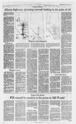
Tuesday, May 25, 1976 5 ii Stanley Williams 'tifW' ri. Alberta highways: gleaming network basking in the pulse of oil PRIMARY HIGHWAYS 1976 TRAFFIC FLOW 1974 L500 3,000 10,000 Average daily vehicles Take a pan of water. When it's perfectly still, spot a drop of oil on its surface, near the centre. In a flash, the water is coated with a film of oil. FAR FROM exaggeration, this experiment illustrates almost precisely what has happened to Alberta highways in the years since oil was found near Leduc in February, 1947.
The water surface represents the province; the spreading oil, the highway system. What caused most of the high-way spreadout? Money money that was coming out of the ground. Oil money. Spread out a 1949 Alberta highways map and lay beside it the 1976 version. The effect of soaring provincial revenues on highway building glares like a neon sign at midnight.
In '49, there were fewer than 560 miles of hard-surfaced roads in the province and very few of them north or west of Edmonton. Now we have 5,380 miles of paved, two-lane roads and another 450 miles of multi-lane divided highways. Today there are roads that were nothing more than wild, impossible dreams 30 years ago such as the Whitecourt-Valleyview cutoff, the Fort McMurray and the Edmonton-Camrose routes. That's not all. Alberta motorists (and teamsters) used 55 ferry crossings in 1949.
There are nine now. When a bridge east of Whitecourt is opened sometime soon, one fewer. Strange happenings Strange things are happening to motor roads these days, some of them every bit as improbable as the Whitecourt-Valleyview cutoff was in 1950. Grade separations for one thing. (All "overpasses" are grade separations but not all grade separations are Campsites.
Interchanges. Railway separations. Illuminated intersections. Paved shoulders. Rest stops only one so far, worth $500,000.
Even airborne traffic cops. Stranger things are in the works. Technicians are experimenting with air flotation, invoking the principle that makes a Hovercraft hover. When this apparatus is a series of platforms slung below a transport trailer, blowing air at one pound per square inch through honeycombed jets, will lift tons from axle loads. It is estimated 100 square feet of this air-assirt package will give a supporting effect of seven tons.
Under a standard semi-trailer, four detachable units could lift 28 tons from a vehicle's wheels, and from the roadbed under those wheels. The experimenters report seeing a prototype unit run over a bird without banning it the one pound per Patterns of planning and services branch has a 100-man staff, technical and clerical, that works on projections as many as 20 years into the future. Planning is faced with combing reports so vague they are sometimes only rumors, and from them assessing the probable direction of population trends, industrial development, resource extraction, recreational planning, whatever. Starting from scratch, it takes years to assemble right-of-way, to survey, engineer, plan and build a primary highway. Invariably, need outruns the builders.
The Syncrude operation near Fort McMurray created tremendous pressure for both new and upgraded access roads. Now Highway 63 is paved all the way to McMurray, and gravelled to Tar Island, 25 miles beyond. Both are in use, but neither is completed. Shouldering has to be done, and strengthening will be required. To what extent? That depends on decisions still to come and at the mo- ment beyond reach.
Problem moves too The projected Dodds-Round Hill coal mine and power plant is anoth-er case. It it goes ahead, it will need a network of high-capacity roads. If opposition successfully moves it to another location, the access problem will move too. The planners must be ready to jump as soon as other arms of government say "go." They know there's work to do, but they don't know where or when. Likewise highways into the foothills, when and if coal-bearing -formations are marked for produc- tion.
And into the Glory Hills north of Stony Plain, should the hint of a brand-new recreational development take root. One key to orderly highway planning is the government's interdepartmental consultative committee, charged with keeping people in ev- ery administrative area in touch with what's going on. The intent is to avoid things like the Windy Point mistake of the late 1960s. At Windy Point in the North Saskatchewan valley west of Rocky Mountain House, the highways department had prepared a roadbed for the David Thompson Highway. But along came the Bighorn Dam project, and a new path around Windy Point had to be carved higher in the hills.
The former new grade is beneath Lake That slip cost around a million dollars and at least in part was due to the left hand of officialdom not knowing what the right hand had up its sleeve. WHEN IT comes to Alberta highways, baby, we've come a long way. No matter what happens to motoring patterns as we know them today, one thing is for sure the gasoline-powered transport era is not going the way of the dodo. The need for big, expensive highways has not diminished. Nor will it diminish this side of the year 2000.
Alberta' major highways as at the end of 1948. The solid lines represent paving; broken lines, gravel surfaces. At right, the primary highway system today, with' broken lines indicating gravel. The black dots show are still in use, and the split one north of Blue Ridge to be replaced a bridge now under construction. the remaining ferries serves a primary Alberta's highway system, 1974, 1948, and 1976.
At left a stylized map shows average annual daily traffic density on major roads, derived from 1974 vehicle counts. The centre panel, based on an Esso touring map, shows hazardous conditions as they are identified, sometimes by building interchanges, sometimes by relocation. Take just east of Edson, where the Yellowhead Highway is being improved to the tune of relocation, two major bridges and a railway separation. The finished job will eliminate the tricky, dangerous route that has carried traffic between Edmonton and Jasper ever since the first gravelled surface replaced the trails and abandoned railway grades that the late Charles H. Grant followed in 1923 when he piloted a Model from city to park gate in 14 hours and 40 minutes.
Then there is landscaping. Road men today don't lay an asphalt ribbon through the countryside and leave it to nature to hide the scars. They plant cover, build drainage systems to counter erosion, and have laws that eliminate the visibility pollution of commercial signs. They're constantly upgrading paving techniques. The newest asphalt mix being applied to highways has three times the load-carrying and durability characteristics of materials used only a decade ago.
What of the future? The transportation department's operational development cubic feet, highway spending followed the same soaring curves. The budget that year put $31,200,000 aside for highways and bridges, including $6,410,000 for the Trans-Canada Highway, for which there was a $3 million-plus reimbursement from Ottawa. In 1959, Provincial Treasurer E. W. Hinman earmarked $48,500,000 for ferries, highways and bridges.
Oil production at that time had reached 130,582,000 barrels; almost 255,450,000,000 cubic feet of natural gas came out of the ground. With some fluctuations, the pattern held into the seventies. In 1974 the provincial treasurer set aside almost $50 million for primary highways and bridges alone. It must be noted that dollars spent do not accurately reflect highway production in terms of road miles and bridges built. Reconstruction of existing routes, labor and material costs, clover-leaf interchanges and so on don't add miles to the highway grid, but they have forceful impact on the spending budget.
Gone are the days when roads were dirt, and dirt cheap. In 1924, according to an old government map, there wasn't a paved road in Alberta. In 1927, the Edmonton-Millet section of Highway 2 was rerouted and improved. Builders then were paying 40 cents an hour for labor and gravel cost 30 cents per cubic yard in place. The Edmonton-Millet project cost $11,261 per mile considered high because there was a lot of tree growth that had to be grubbed out.
Moreover, the foremen complained of delays caused by heavy traffic through the work, as many as 800 cars in one day. Highway builders nowadays have other problems. Like "Indianapolis curves," the high-banked bends that keep most (but not all) speeders out of the ditches. Like changing traffic patterns; while energy constraints may reduce pleasure driving in the foreseeable future, increased commodity traffic more makes up for any saving of pavement wear and tear. Engineers have to rectify The Journal lot prices where ferries dot marks by None of highway.
Color-coded history Back in the 1920s, when tourists and touring cars were noticeably apparent in Alberta, main highways were color-coded for motorists' convenience. Telephone poles carried white bands bordered by stripes colored according to route. Highway 3, from Crowsnest Pass across the south of the province, was the "Red Route." Macleod (it was not "Fort Macleod" then) was linked to Calgary by the Blue Route. From Calgary north, through Edmonton and beyond to where the road petered out above Athabasca, lay the Black Trail. The Yellow Route, from end of recognized road at Entwistle east to Lloydminster, years later became the Yellowhead Highway.
There was another Yellow in the southeast, be square inch pressure exerted by the air jets is only one-fifth of that of the average man's footprint. It is too early to project air-assist as the answer to the freeze-and-thaw cycle that annually puts the brakes on movement of heavy goods over thousands of miles of highways large and small. One day, though, it might do to road bans what bridges have done to the old-time ferry; consign them to the discard pile. It would be less than accurate to attribute the explosion of Alberta highway building in the last three decades entirely to revenue derived by tapping into oil and gas resources. But it's fair to say that since Leduc, oil-found money has more than greased the ways.
Since 1948, the old public works department, then the highways department (1951-1974) and now the department of transportation have put into capital road building projects. To see what this $1.2 bil- to travel 1960 Alberta section of Trans-Canada Highway completed. Swan Hills connection completed. Four lanes completed between Edmonton and Calgary. 1964 Ponoka-Lacombe section of new Highway 2 completed.
1966 Work begins on rebuilding Yellowhead 16 between Edmonton and Lloydminster. 1968 Sherwood Park Freeway completed. David Thompson highway open to traffic. 1969 Hinton-Grande Cache 'connection opens. Highway 2 twinned from Ellerslie to Nisku corner.
1970 Four lanes completed from Calgary to Banff National Park. 1971 Edmonton-Fort Saskatchewan highway rerouted. Highway 14 rebuilt between Edmonton and Camrose junction. 1975 Fort McMurray highway paved. Bridge over Peace River links Fort Vermilion to provincial road grid.
council be not one of these families owns a home at the present time. It is becoming progressively more difficult for young couples to own homes in Edmonton. However, through the co-operation of the department of consumer and corporate affairs, the Alberta Housing Corporation, NAIT, and the city of Edmonton, it is still possible for these families to form building co-operatives and build their own homes. Twenty-five families have been successful in building their own homes and now 140 families are anxiously waiting for city council to make a decision on the price of lots in Mill Woods. If the price of lots increases as much as 200 to 300 per cent these families and other families in a similar situation will not be able to afford to build homes.
Some concern has been expressed that these families are speculators. What have they got to gain by selling their homes? Should they sell their homes they must purchase lion bought, compare the 1949 and 1976 road maps. In 1949, what pavement had been laid down was available largely to motorists based at Edmonton and Calgary. Today there are mighty few communities not served by hard-topped highways, and only a handful not served by all-weather roads. Going farther into the rural scene, a whopping 84 per cent of Alberta's current farm population is within three miles of a primary or secondary highway.
And the transportation department (so formed in 75) now lives up to what its name implies. It has responsibilities related to all forms of transport, be they railways, airports, landing strips, roads, bridges, ferries or metric "mileposts." It runs a railway and an airline. It has surveyors, planners, cartographers, engineers, and stenographers who spend their working hours dealing with people and vehicles travelling on or above the province's 255,285 square miles. All in all, the transportation department has a payroll that embraces the equivalent of 4,135 "man-years." It has 2,135 full-time employees, and seasonal workers who put 2,000 man-years into jobs geared to weather conditions. Back in 1948, the capital spending on main provincial highways, bridges and district roads totalled $8,800,000 roughly the cost, in today's terms, of one major interchange and two big bridges.
Ernest Manning, then premier and provincial treasurer, began beefing up highway budgets as soon as the Leduc oil boom gathered head- -way. Cautiously at first he upped the 1949 capital road allotment to $10 million. And noted: "Our capital expenditures are being financed almost entirely by revenues accruing from the depletion of our oil and other natural resources." Petroleum production in 1948 was 10,973,583 barrels worth Natural with production at 60,300,000,000 cubic feet, was valued at $3,000,000. By 1954, when oil production had climbed to almost 88 million barrels, and gas wells gave up 109,221,000,000 Letters to sensitive to other homes to live in and incur the cost of the transactions. I sincerely hope that our aldermen take a close look at the issue of lot prices in Mill Woods and be sensitive to the aspirations of the lower and middle-income groups who wish to continue to make Edmonton their permanent residence.
Gordon Shand Edmonton Restricted weapon The solicitor-general for Alberta has tried to take unto himself authority clearly vested in the federal government under the Criminal Code of Canada. Mr. Farran has turned his attention to the AR-7 survival rifle which has been sold quite openly and legally in Canada for approximately 15 years. His obvious contention is that this rifle falls into the "restricted weapon" category laid down in the Criminal Code of Canada, which Mileposts 1923 First car driven from Edmonton to Jasper Park gates. 1949 Fanners west of the Pembina River raised $2,000 in three days, and the government contributed $3,000, to open a road between Wildwood and Mayerthorpe which then had no direct connection with Highway 43.
1952 Tote road open between Whitecourt and Valleyview. 1953 Highway 2 completed to the B.C. border between Demmitt and Tupper Creek. The Calgary-Drumheller highway paved. 1955 Whitecourt-Valleyview cutoff completed, bringing the Peace River country 80 miles closer to Edmonton.
1956 Yellowhead highway blacktopping between Lloydminster and Jasper National Park completed. 1957 First car driven from Fort McMurray to Edmonton, taking 18 hours to cover 462 miles via Wabasca and Slave Lake. Will I am convinced that our city aldermen do their best to make decisions that will benefit the residents of Edmonton and the city of Edmonton as a whole. However, I often wonder about their priorities and about the amount of factual evidence upon which they base their decisions. In particular I am concerned about the prices of lots in Mill Woods.
Mill Woods was developed to provide housing for low and middle-income families. Do the city aldermen wish to provide for housing within the means of the average wage earner or to put more coppers into the kitty? From information obtained from members of building co-ops, concerning 158 of the families interested in purchasing land in Mill Woods, the majority are young married couples with children. The total average wage of each family is $13,907 per year. Each family has managed to save approximately $2,000 to put towards a home. Without exception, in Mill Woods? tween Strathmore and Medicine Hat today's Trans-Canada.
The Edmonton-Cooking Lake-Chauvin road was a northern Blue Route. From Wetaskiwin to Provost, green was the color to follow. Through cities and towns, striped telephone poles were found block by block; sometimes, when routes came together, poles would carry two colored markers. Out in the country, markers could be miles apart. At junctions, a block letter or superimposed on the colored marker meant the route in question turned at the next corner.
A horizontal band of color meant "don't turn here." The only other officially recognized sign was a big which signified either "railway crossing" or "danger." point and made sense, and they didn't speak too long and repeat themselves like the others did. To make matters worse, they couldn't make decisions even after they'd discussed items for hours on end. Mayor Cavanagh certainly didn't distinguish himself. He seemed weak and unsure of himself and I was shocked by the number of councillors who didn't follow the meeting procedures and often were discourteous to their fellow members. A couple acted like buffoons rather than serious elected officials.
I went away very unhappy and uneasy. I have no doubt that this is the most impractical and unproductive council this city has ever had. One has to be worried when a council can't even discuss dogs with a reasonable degree of intelligence. I hope they read this letter and get the message and straighten out. Or maybe that's too much to ask.
Darlene McLean Edmonton states: "any firearm that is less than 26 inches in length or that is designed or adapted to be fired when reduced to a length of less than 26 inches by folding, telescoping or otherwise." The AR-7 cannot be folded or telescoped. It can be fired with the barrel and action removed from the stock, in which case its overall length is less than 26 inches. This situation exists with virtually all rifles available on, the market today, many of which, like the AR-7, are less than 26 inches long when the barrel and action are removed from the stock. To suggest that this is in contravention of the Criminal Code is stretching a point beyond the limits of credibility! Even if this were not the case, the Criminal Code clearly states that the responsibility for placing a firearm in the "restricted" category rests with the governor-in-council, not with provincial solicitors-general. In view of the foregoing I strong ly suggest that owners of AR-7 rifles should not register them with any police agency, and those who have done so should demand an immediate return of all records pertaining to the registration of these rifles.
R. A. Watt Busby Council inaction? I had the experience I certainly can't call it a pleasure of watching city council in action (inaction?) during a recent marathon sitting. It was an eye-opener! What a sorry spectacle! Most of the council members talked too much and I couldn't believe my ears when I heard some of the things they said. So many of the comments lacked common sense, bordering on the incredulous.
The only members of council who impressed me were Aid. Hayter and Newman. They stuck to the (WSw'jt.
Get access to Newspapers.com
- The largest online newspaper archive
- 300+ newspapers from the 1700's - 2000's
- Millions of additional pages added every month
Publisher Extra® Newspapers
- Exclusive licensed content from premium publishers like the Edmonton Journal
- Archives through last month
- Continually updated
About Edmonton Journal Archive
- Pages Available:
- 2,094,959
- Years Available:
- 1903-2024