The San Francisco Examiner from San Francisco, California • 89
- Publication:
- The San Francisco Examineri
- Location:
- San Francisco, California
- Issue Date:
- Page:
- 89
Extracted Article Text (OCR)
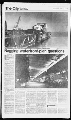
ipi rvr -i rr r- Mr Ksn "rv ran Including the Dec. 19, 1979 S.F. Examiner Page B-1 Daly City area 7 -'H 1 WITT- lu. -if Vvr. iiVL, 11 imwAi If ri? Examiner photos by Chris Hardy Piers 42, 44 (mislabeled here as 14) and 46, where proud ships used to dock, are structurally unsound, lacking roofs and walls i 6 I I gging watenronf-plan questions By Gerald Adams IT WRONG to cede a choice park site on the San Francisco waterfront to a hotel operator? Does the new blueprint for the waterfront's future kill chances for The City's struggling maritime i I industry to grow? Or is the format, as Planning Commission head Toby Rosenblatt says, a way to turn San Francisco's downtown shoreline into "a very-exciting place," as well as "the best possible compromise," after years of scrapping over this nearly two-mile-long strip? Such lingering questions are being disputed by those charged with deciding the future shape of the northeastern waterfront, the portions on either side of the Ferry Building, from Pier 7 at the north to China Basin at the south.
The dispute grows this week as officials of the Port Commission and in weeks to come the Planning Commission, the Redevelopment Agency and, finally, the Board of Supervisors prepare for Jan. 9 when port officials are scheduled to decide on the Northeastern Waterfront Total Design Plan and, thereby, the eventual character of the main waterfront. If they choose to proceed with the current design, the shore will be cleared including the Embaicadero Freeway for the biggest land-use switch here since completion of such landmark urban renewal projects as the Embarcadero Center-Golden Gateway and Diamond Heights. The most recent controversy over the plan is this: Should The City allow a privately developed hotel to locate in a public park? The question flared up last week before the Port Commission, with Commissioner Alan E. Rothen-berg later promising "I'm going to hard-line it." He vowed to get a (KJO- to 800-room structure moved from inboard of Spear Street to the site of a three-acre park planned for the water's edge because he fears the present site will cost the port badly needed revenue.
Sure to oppose Rothenberg's move is Robert Katz. a Telegraph HU1 activist, who argues: "We should not be giving away public land, which is badly needed for open space, for a private development." Katz also fears that the developers, Chris Redlich and Ellett G. Horsman of Marine Terminals would be able to break the Urban Design Plan's shoreline height limit of 84 feet if the change is permitted. (Architects for the developers say their model indicates a 200-foot 15story height, well within the 240-foot limit on the waterfront plan's indicated site, but over the shoreline limit.) Rothenberg's argument against the hotel's so'alled inland site: The port needs rental revenue from the hotel, hich he estimates at $1 to $2 million a year, to finance its expenses. If the hotel stays on the presently indicated site, on lots owned by the state of California and former San Francisco Supervisor William Blake, says Rot hen-berg, the port would lose that rent.
Developers of the hotel have another concern: a fear that if the Embarcadero Freeway manages to outlive efforts to tear it down, their inn's guests would forever be kept awake and by its traffic and shadowed by its concrete. For their part, conservationists, if they would tolerate any development In Pier 1 Ferry Building area, planners envision offices, shops, restaurants and space for long-term tenants, such as the World Trade Club estimates from S66 million to S71.fi million, including the expense of freeway removal. Potential funding sources include federal, slate and local bonds, tax revenue and grams from multiple sources, as well as private sources. In the wake of the departure of major shipping lines to Oakland and elsewhere. Pier 1(5 is falling into Bay, its metal beams rusting away: grass is growing on the unused flat ol Pier Piers 42.
44 and 46. where the proud Dollar and. later. President ships once docked, lack roofs and walls, and are structurally unsound. And.
in an incongruous use of docks thai no longer attract ships. Pu rs 1 and 7 are parking lots. maritime use. including the following facilities for break-bulk (non-containeri cargo: Piers 26, 28, 30. 32: and Piers 34.
36 and 38 as repair facilities. (To the north, or odd-numbered side of the Ferry Building. Piers 9 through 35 would remain in maritime use. I Development of Piers 3 and 24 as berths for historic vessels. Retention, despite the move of post office distributing facilities to India Basin, of Rincon Post Office with its historic Anton Refregier murals (Rincon Annex has just been named to the National Register of Historic Plaeesi.
The southern portion of the block would he adapted to housing, according to the waterfront plan. Public costs of all this range in Pacific rail lines. Proponents of the yacht harlxir argue that it's needed to supplant that South of Market area's factory-warehouse image with one that would enhance the residential market. They also argue that The City now needs housing more than it does piers and that the central waterfront provides more than enough space between China Basin and Hunters Point to accommodate port growth. Soules argues with the last point, too.
He says that filled land to the south is too unstable to support the 1,000 pound-per-square-inch gantry cranes needed to run a big-volume container-ship operation. Controversial aspects of the plan tend to obscure the considerable selling points of this and companion plans, which include: Destruction of the Emlwrcadero Freeway and its replacement with a landsca)ed surface roadway, the result of which would be to reoen a Bay vista that the elevated roadway has blocked since 1957. The Embarcadero would be rerouted to accommodate a new park-plaza in front of the Ferry Building, more open space at the foot of Folsom Street and a marina park inland at the end of King Street. Replacement of the Belt Line railway with the first new streetcar line since the a service using old- time trolleys (for color! that would connect the Southern Pacific depot on Fourth Street with Fort Mason. Replacement of rotting, unused piers with park-like open space and a waterfront promenade.
Transformation of Steuart Street, bayward of Rincon Annex Post Office, into a landscaped pedestrian mall. Rebuilding and. because It would remove the elevated freeway, revealing the Ferry Building. That $.6 million project, including restoration of the smaller Agricultural Building to its south, would provide interim parking at Pier offices; shops (but not tourist boutiquest restaurants: a continuing home for the World Trade Club and other long-lease tenants; remodeling of the Ferry Building's maze-like corridors into through passageways, and continued development of the bayside as a ferryboat terminal. A $2 million refurbishing (described as less than lavish) of the passenger ship terminal at Pier 35.
Construction of 2200 dwelling units inland from Piers 38. 40 and 42, together with restoration of the historic Oriental Warehouse in that section. This, like the park between Howard and Harrison streets, would require Redevelopment Agency participation because of the need to assemble varknl parcels of land. Retention of all piers now in on the park, would prefer it to be used for a restaurant comparable to New York City's in Central Park. These arguments have generated enough static to delay the Port Commission's decision over the northeast waterfront plan for three months.
Because of that, the Planning Commission has had to postpone its own consideration of the plan. The other leading controversy concerns the effect of the plan on shipping. Former port chief Thomas Soules is the leading spear carrier for those concerned about the future of maritime development here. And even he concedes that he's fighting a lost cause in opposing portions of the plan. He neverthless thinks that the Port Commission has cost itself as much as S3 million in future annual revenues by-its, October decision now written into the waterfront plan to allow transformation of Piers 40 to 4fiA into a 400-boat yachting marina, unless maritime needs dictate otherwise.
If the waterfront design' is approved, Soules cautions, one of its chief features a new residential and neighborhood shopping complex, on blocks bounded by King, Brannan. and Second streets and the Embarcadero would preclude those piers from ever connecting to nearby Southern Correction owners have brought pressure on residents to move or thai the hotel is anything but a ivsihsI-ableand profitable establishment tuii. -tioning within the Ixninds of It gal propriety is without Ixisis. The Examiner regrets any unfavorable impression of the Colonial Hotel created by the article. In an Examiner story on Nov.
14. the Colonial Hotel, located on a lower Nob Hill block of Bush Street, was mentioned as one of those hotels where tenant have complained about conversion from residential to tourist status and erroneously indicated that the hotel management had removed the telephone of one of the tenants. Any inference that the hotel's.
Get access to Newspapers.com
- The largest online newspaper archive
- 300+ newspapers from the 1700's - 2000's
- Millions of additional pages added every month
Publisher Extra® Newspapers
- Exclusive licensed content from premium publishers like the The San Francisco Examiner
- Archives through last month
- Continually updated
About The San Francisco Examiner Archive
- Pages Available:
- 3,027,574
- Years Available:
- 1865-2024