Pensacola News Journal from Pensacola, Florida • 6
- Publication:
- Pensacola News Journali
- Location:
- Pensacola, Florida
- Issue Date:
- Page:
- 6
Extracted Article Text (OCR)
6A Pensacola News Journal Saturday, August 5, 1995 AFTER ERIN: IMPACTING OUR FUTURE wy mil OKs raw and uninsured damage. ERIN'S COST 60 of the city's 68 traffic lights damaged $1 00,000 to $250,000 expected in overtime costs Civic Center damage severe and city has $500,000 deductible on insurance Cost of operating garbage drop-off sites around-the-clock: unknown By Scott Streater News Journal staff writer Escambia County hadn't suffered a direct hit from a hurricane in nearly seven decades, so it probably wouldn't surprise many to know the county had no formal disaster rebuilding plan. That is, until Friday. The Escambia County Commission approved an emergency ordinance adopting a Post-Disaster Redevelopment Plan that outlines how the county goes about putting the pieces back together after a natural disaster like Erin. Without the plan, the county would have a lot of trouble getting federal disaster relief funds.
County Attorney David Tucker told commissioners the county has nothing in place like the redevelopment plan. Commissioners unanimously approved adopting the plan without reviewing it, but retained the option to change parts of it if they want. The ordinance is now a part of the county code. In a nutshell, the plan sets priorities on what should be attended to after a disaster, beginning with debris removal and the repair of damaged roads and other infrastructure. It also allows the chief building official to place a 72-hour "It's'the type of thing where yo'U get it done and you worry about paying for it when the time comes," Neron said.
"A lot of it is going to be personnel and equipment. "For us, it's a matter of debris," he said. At least one expenditure will be repairs to the roof and to water-damaged areas inside the Pensacola Civic Center. Though no cost estimate was offered, and the center is insured, Evans said the county has a $500,000 deductible. Pensacola City Manager Ed Hinkle said most of the coets the city will bear will be in overtime moratorium on all building permits if the governor declares a disaster in the area.
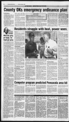
That has not been imposed as yet. Although officials said it was too early to give any concrete cost estimates, both county and city leaders say they think there is enough in the current budgets to absorb the cost of the unexpected natural disaster. Assistant County Attorney Bill Neron said money could be routed from other capital expenditure projects to pay for overtime during the cleanup of debris. mth -heat. Ms striai powe jS If i 1 1 Gary Santa Rosa County Commissioner David Kessler, left, and Gov.
Lawton at Navarre Beach. The governor and his aides toured the area Friday. Hinkle estimated overtime costs for employees will be $100,000 to $250,000. The reserves estirhMed in the city's proposed fiscal 1996 budget are $800,000, but that's based on how much money is left over from the current Tom Bedell, the city's senior traffic engineer, said 60 the city's 68 electric traffic to be replaced. Compounding, the problem is the fact that electricity out, Bedell saidr.no one's sure whether the lights.will actually work when power restored.
"It's rather frustrating," he said. woe Highway. About 60 people were in the sheU ter Friday night. Emergency Medical Servicestif- ficials said numerous patients who have called arrived at local emergency rooms for minor injuries and heat-related illnesses are on the verge of overloading the 911 system. "This may result in life-threatening ambulance response delays to critical illnesses and injuries," EMS spokesman Bob West said, "The potential to overload 'ihe emergency rooms exists." EMS asked that patients a' personal physician, family care center or local clinic, if Military regroups The Naval Air Technical Train, ing Command construction site at Pensacola Naval Air Station'Mf-fered hundreds of dollars in damage, said Robert Van Cleave, project 'Bui he said the damage won't delay'the project completion by late 199p7 Eglin Air Force Base in Okajopsa County estimated damage in()th9 millions.
Hurlburt Field near Navarre'tfad some minor building damages mostly to trees, power lines rooftops. Chiles' tour Chiles and his entourage, flying in two National Guard helicopters, made a gritty landing on a sand-covered parking lot od'iSta-varre Beach. Chiles ordered the van to stop at the crumpled home of a Rosa sheriffs deputy on White Sands Boulevard. The entrance of the A-frame was bowed like a musical saw. Some windows were by wind gusts.
v.J" "Kinda bowed out on ya'arlit-tle?" Chiles asked Deputy Hob Johnson, who was loading furniture onto a trailer that already contained a stereo and a pianb' The next stop was Pensacbla, where Escambia County Administrator Barry Evans told Chiles-he was dissatisfied with official forecasts that led residents to bejjfcye the storm would strike to the yest. News Journal staff writers Rick Barrett, Scott Streater, Charles Ashby, Lori Gait-lot, Kimberty Blair, Jim Ash, Scott Schon-auer and The Associated Press contributed to this report. fect and the observations are not perfect, you very rarely get a' perfect forecast," Lord said. A ft If One expected improvement is the introduction of a $43 million reconnaissance jet aircraft that will supply crucial atmospheric measurements. The aircraft' "will not be ready for use until the 1996 hurricane season.
Florida Panhandle later this morning." Strike probabilities: Apalachicola 99 percent. Panama City 99 percent. Pensacola 80 percent. ZZ Mobile 66 percent. GulfparfZ 55 percent.
New Orleans percent. 6 a.m. "Erin is moving toward the northwest near 13 mph. The center of the hurricane could reach the western Florida Panhandle later this morning. There is still a possibility that Erin could move more west-northwestward." Jiij 8 a.m.
'Erin is moving toward the northwest near 12 mph. On this course the center of the hurricane would reach the western Florida Panhandle later this morning or early this afternoon. There is still a possibility that Erin could move more west-northwestward." 11 a.m. "Hurricane1 Erin made landfall near Pensacola Beach Florida at about 10:30 with sustained wind speeds tentatively estimated at 85 mph "and gusts of about 100 to 1 10 mph." fTJCarl Wernicke Columnist When the going got tough, the tough got going OK, I'm convinced. Hurricanes are not a good thing.
But people being the strange beasts we are, it 'is bad things that bring out the in us. So amidst all the wreckage, the people of Northwest Florida got to show off just a little bit Thursday and Friday. Frankly, after dealing with people all over town, I'm proud of this community. It has a spirit I think will help carry it through some hard days ahead. By now those of you without electricity and air conditioning are tired of it.
Many have discovered you lost more than you thought. Even if you didn't personally lose a roof or a car, other things have, in their passing, taken with them a piece of Pensacola we've always had. Like in East Hill and the Seville district, where trees that were mature before you were born, lie uprooted and splintered. Like in McDavid, where J.D. and Paula Jernigan lost the oldest standing home in the community.
And now you've discovering that you're 75th on the list for tree removal, 50th on the roofer's list and that everything in your freezer is soft and warm. But none of that takes away from the good things: Was everyone in Pensacola listening to WCOA? Don Priest, Don Parker and Luke McCoy talked an entire community right through the storm. Despite howling wind and driving rain, their steady, friendly presence taking calls, dispensing information somehow made it all better. And since modesty prevents blowing the News Journal horn, I'll quote Dick Griffith on Friday: "It was just amazing to me to find a newspaper in my driveway at 5:30 this morning." Mine was there, too. A young girl from Gulf Breeze called in to WCOA during the storm to ask if volunteers were needed anywhere.
A woman called to say her husband had a winch on his truck and would, at no charge, pull trees off cars or driveways. Neighbors who hadn't talked in years got reacquainted during the eerie, stifling-hot passage of Erin's eye. People squirted out of their houses like toothpaste when the wind and rain stopped and the sky lightened. Some hammered up plywood or dragged fallen limbs to the street. Others checked on neighbors, like the woman in my neighborhood whose first task was to check on an elderly lady living alone.
We found out the girl across the street had gotten married, and I don't know who was surprised more myself or Tom Keith, a YMCA basketball buddy to discover we live a block from each other. After the storm, complete strangers at Brown Marina on Bayou Chico helped each other secure loose lines on boats owned by people they didn't know and have never met. Many people say driving was treacherous, but I've found drivers surprisingly cooperative at intersections with downed stoplights. Drivers throughout East Hill, downtown and west into Warrington calmly pretended they were at four-way stops. Same thing at the numerous fallen trees across Scenic Highway, 12th Avenue and elsewhere: quietly and calmly took turns waiting in line to pass around the blockages.
All in all, across the Pensacola area, it was an impressive perfor- mance. Why don't we do it again in, say, 150 years? Cart Wernicke, who has lived in Pensacola all of his life, is assistant opinion editor for the News Journal. He can be reached at 435-8545. Or whte P.O. Box 12710, Pensacola, 32574.
4 jWO 1 FROM 1 A Santa Rosa Island, a barrier island that includes Pensacola Beach and Navarre Beach, absorbed the brunt of Erin. Pensacola Beach reopened to residents, leaseholders and key business personnel at 11 a.m. Friday but will remain closed to others until electrical power is fully restored. Navarre Beach reopened to residents Thursday night and to the general public at 1 p.m. Friday.
Other hard-hit communities include Santa Rosa's Milton, Bagdad, Pace and Pea Ridge, as well as some of Escambia's upscale suburbs near Escambia Bay. 'A big old giant' Homes lay crushed by aging pine and live oak trees. Some cars were hidden under large branches. "It looks like a big old giant just came in and ripped those big oak trees right out of their root," said Santa Rosa sheriffs Lt. Charles Sloan.
"It's really amazing to see what was done to those huge trees." Erin dumped an estimated 8 to 10 inches of rain on the Pensacola area over about four hours Thursday, the National Weather Service estimated. Thunderstorms on Thursday night and Friday morning added another 1.25 inches. Today's forecast calls for highs in the upper 80s, scattered thun-dershowers, and a gentle south wind of about 10 mph. All in all, said Escambia County emergency operations spokesman John Teelin, the area fared well in its first direct hurricane hit since 1926. "If Pensacola has to have a hurricane every 69 years, I guess Hurricane Erin is the one I want." Big headaches For most area residents, the No; 1 headache seemed to be the power outages.
Gulf Power Co. and out-of-state utility crews restored service to 105,755 customers Friday, leaving 109,245 without power, according to spokesman John Hutchinson Full service might not be restored for about a week, he said. Crews will work around the clock through that period. Teelin said power outages were creating problems beyond the lack of lights and cool air. iomputer FROM 1A What makes this hurricane model more accurate is its ability to convert vast amounts of information into a high-resolution interpretation of what the storm will do next.
"A model is only as good as the data you feed into it," said Morris Bender, one of three researchers who developed the hurricane tool. "If you don't have initial atmo Here's a chronology of advisories and "strike probabilities" issued by the National Weather Service. The strike probabilities show the chances the center of a hurricane will pass within 65 miles. TUESDAY 10 p.m. "The center should reach the Florida East Coast very shortly and is forecast to move over the Northeast Gulf of Mexico in 24 hours and inland again in 36 hours in the Florida Panhandle." Strike probabilities: Apalachicola 37 percent.
Panama City 35 percent. Pensacola 29 percent. WEDNESDAY: 4 a.m. "The center of Erin is moving over Central Florida. (It) will continue moving across the Central Florida peninsula this morning and emerge over the extreme northeastern Gulf of Mexico around midday." Strike probabilities: Apalachicola 41 percent.
Panama City 35 percent. Pensacola 28 area hi! McCrackenNews Journal photographer Chiles assess property damage 1 Insurance claims A team of 117 Allstate insurance adjusters from all over the United States were in Pensacola on Friday assisting local agents with claims. Allstate classified 66 customers' houses as uninhabitable, sight unseen, said' spokeswoman Leslie Chapman-Henderson, whose company insures nearly one-fifth of the state's homeowners. Escambia County schools suffered at lpast $2 million in damage, officials said. Workman Middle School possibly hit by a tornado, lost the roof on the main building and has significant water damage.
Some students, set to return to school Aug. 14, may have to be temporarily relocated. Pensacola's disaster-relief shelters were consolidated at Olive Baptist Church, 1836 N. Davis rently the world's most technologically advanced hurricane forecasts, Bender said. Although forecasters had initially expected the fifth storm of the Atlantic hurricane season to push ashore near Apalachicola, that prediction changed as the eye jogged west and moved parallel to -the Panhandle.
the model is not per Mobile 50 percent. Gulfport 49 percent. New Orleans 39 percent. Midnight "Erin strengthens to a hurricane. On this track Erin will move near and parallel to the coast of the Florida Panhandle this morning near southern Alabama and inland across the Mississippi or southeast Louisiana coast Thursday.
Strike probabilities: Apalachicola 99 percent. Panama City 99 percent. Pensacola 59 percent. Mobile 49 percent. Gulfport 48 percent.
New Orleans 38 percent. THURSDAY: 2 a.m. "Erin has moved toward the northwest near 14 mph over the past few hours. If (this) motion persists the center would move closer to the extreme western Florida Panhandle by midday." 4 a.m. "If the more northwestward motion persists the center could reach the western Pensacola "The power's the big problem," Teelin said.
"That's the fine that makes it hard to pump gas. That's the one that makes it hard to get ice." The No. 2 headache seemed to be felled trees and debris. County engineer Cindy Anderson said crews will begin hauling yard trash placed at curbside today. The crews will make daily pickups through Aug.
22. A third headache is the damage at the Pensacola Civic Center. About three-fourths of the roof is gone and there's water damage on every level, director Carol Pollock said. A team is coming in today to assess damage. Events in August and September likely will have to be postponed or relocated.
Water woes Santa Rosa residents, except those in Milton, are being urged to boil or chlorinate drinking water program spheric flow right, some small changes can make a big difference." Ron McPherson of the National Weather Serves in June said, "We expect this model to result in more accurate forecasts of where a hurricane will strike and thus more precise estimates of coastal zones to be evacuated." The hurricane program does this 10 a.m. "The center of Erin is already moving into the northeastern Gulf of Mexico. Tropical Storm warnings have been extended along the Gulf Coast to Pensacola." Strike probabilities: Apalachicola 72 percent. Panama City 63 percent. Pensacola 42 percent.
2 p.m. "A hurricane warning is in effect along the Gulf Coast. On this track Erin will move parallel to the coast of the Florida Panhandle during the next 6 to 12 hours." Strike probabilities: Apalachicola 84 percent. Panama City 71 percent. Pensacola 49 percent.
Mobile 38 percent. Gulfport 34 percent. New Orleans 26 percent. 4 p.m. "Erin is expected to reach hurricane strength over the next 12 hours.
A west-northwestward track about 15 knots is expected to continue. This track brings the center of Erin near the MississippiAlabama coast in 24 hours." Strike probabilities: Apa because of possible contamination from broken water lines. "Everyone in the county should' do it until further notice," said Emergency Management Director Tom Roche. Water service was restored in Santa Rosa Friday, but there were still areas without sewer service, including Milton neighborhoods. Sewer service is out because some of the city's sewage lift stations lack electricity.
"It has been my biggest frustration," said William Whitson, Milton city manager. In Escambia, the Escambia County Utilities Authority lifted its "boil water" advisory after a complete check of the system revealed no contamination. The ECUA water system was working, although there was low pressure in some areas because some wells didn't have electricity. predicte with a Cray C90 supercomputer, one of the world's most advanced scientific instruments, which has computing power equivalent to between 500 and 1,000 desktop personal computers. Ten years ago it would take a computer a full day to turn out a 72-hour storm forecast.
The Cray supercomputer requires just 20 minutes to complete what is cur- lachicola 84 percent. Panama City 71 percent. Pensacola 49 percent. Mobile 38 percent. Gulfport 34 percent.
New Orleans 26 percent. 6 p.m. "Erin will move near and parallel to the coast of the Florida Panhandle tonight and inland across the Mississippi or southeast Louisiana coast on Thursday morning." Strike probabilities: None given at this hour. 8 p.m. "Erin will move near and parallel to the coast of the Florida Panhandle tonight and inland across the Mississippi or southeast Louisiana coast on Thursday." Strike probabilities: None given at this hour.
10 p.m. "Erin will move near and parallel to the coast of the Florida Panhandle tonight near southern Alabama and inland across the Mississippi or southeast Louisiana coast on Thursday." Strike probabilities: Apalachicola 99 percent. Panama City 99 percent. Pensacola 60 percent..
Get access to Newspapers.com
- The largest online newspaper archive
- 300+ newspapers from the 1700's - 2000's
- Millions of additional pages added every month
Publisher Extra® Newspapers
- Exclusive licensed content from premium publishers like the Pensacola News Journal
- Archives through last month
- Continually updated
About Pensacola News Journal Archive
- Pages Available:
- 1,989,878
- Years Available:
- 1900-2024