Petaluma Argus-Courier from Petaluma, California • 10
- Publication:
- Petaluma Argus-Courieri
- Location:
- Petaluma, California
- Issue Date:
- Page:
- 10
Extracted Article Text (OCR)
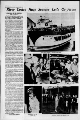
10 Prtalnma flrsusf'Coatfft Oct 21, 1965 A Go Cruise River Mt Huge Su ccess- am is A- x-J. illl Harbor Princess travels past Street carrying local throng lw 4-Uay' ''wlfe. ''ro)uuw I' "-ra "'-v Vijfv.J. Pr- y'-Vw- PETALUMA RIVER HISTORY (ONCE OYER LIGHTLY) Petaluma's Community Guild sponsored the boat trip down Petaluma River Saturday night. The following is a portion of Petaluma River History (once over lightly) prepared as a keepsake by Ed Mannion.
Probably the first extensive penetration up the waterway was made in 1776 by a small boat from the Spanish ship San Carlos. With Captain Fernando Quiros in charge, the explorers thought the Marin countryside was an island and they could sail all the way to Bodega Bay. A plan was suggested a few years ago to make the dream come true by digging a canal from Petaluma to Bodega. Little known is the fact that Russian sailors from Fort Ross navigated the estuary, now officially called a river, to trade at the Petaluma Vallejo Adobe following 1834. Game hunters for the San Francisco market brought their whale boats up to the head of navigation at the mid-century mark: Several of them knew a good thing when they saw it and stayed to become the city's founding-fathers.
In spite of its relatively short distance of 16 miles, Petaluma River once ranked third in the amount of traffic carried along the state's water highways. Steamboats, including many paddle-wheelers, carried much of the tonnage. Scow schooners also played an important part The flat-bottomed, square-ended workhorses that usually were schooner-rigged and averaged about sixty feet in length didn't look graceful, but they were handled well by two or three men and could glide over shallow water with ease. i On the spot where the city float is tied up today, the steamer Georgina blew up in 1855. Such explosions and fires (more to follow) may- seem like strange events to be talking about; still, such spectacular-news items act as historical benchmarks which can highlight other facts.
For instance, the Georgina incident is proof such vessels did dock in downtown Petaluma despite the popular supposition that, in the early days, they never ventured above the Haystack Landing. The famous "Gold Landing" is to the left in McNear's Canal, below the Street Bridge. On the east bank of the canal can be seen at low tide the hulk of the second steamer named Petaluma. It burned at the nearby wharf in 1914. Six years later, the first of two rear-end paddlers called Gold was destroyed in the same way at the same spot.
Immediately below the railroad swing bridge, on the right, is a cut-off section of the old stream bed where bones of the Red Jacket lie buried. This wood-burning craft probably was the first boat of its type to arrive in Petaluma over a century ago. Later, under the name of Kate Hayes, it was anchored as a warehouse and was covered eventually by fill from the adjoining rail roadbed. Opposite on the lett can be seen a small indentation which is all that remains of the original river bed once reaching to the intersection of Casa Grande Road and Lakeville Highway. Promoters, including Gen.
Mariano G. Vallejo, started a short-lived community called New Town at this point in 1852. A landing at the spot was given as one of the reasons why the Old Adobe and surrounding area was seriously considered as the site for the University of California. Although present cuts below Petaluma belie the tortuous course of the old stream as it meandered over the valley plain, navigational problems weren't too bad up to the Haystack Landing. Barges still operate from this well-known locality that once included a railroad turntable, the Rudisill Hotel and a pit for bull and bear fighting.
The wide curve above Lakeville is commonly known as Cloudy Bend. On May 25, 1883, the steamer Pilot blew up on the turn killing nine passengers. An old picture shows a boat wharf almost in midstream opposite Lakeville. Hidden in the hills to the east is the historic locale of Lake Tolay now drained and used for farming purposes mentioned by Padre Jose Altimira in 1823 while exploring for a mission site eventually located at Sonoma. Lakeville got its name from the ancient body of inland water.
About a mile below; keep your eyes peeled for rotted pilings which mark the site of Donahue, named for the famous Peter Donahue. His steamboat and railroad terminus lasted from 1870 to 1884. Then the San Francisco and North Pacific Railway loaded several of its buildings onto barges and hauled them to Tiburon. The original depot is still there. Although Donahue and New Town are long gone, their names still appear on some modern maps.
Farther along on the left, a home built within the shelter of three brick walls comes into view. The walls are remnants of a winery. Grape vines covered the eastern foothills when Senator James Fair (the Comstock silver king) owned the property. How many of you have seen the monument to Indian Chief Francisco Solano standing in front of the public library at Fairfield? There has been a great deal of argument where the huge statue should be placed in Solano County to mark the chief's burial spot. Well, the evidence is about 99 per cent certain that Solano (Sem-yet-ho, the Mighty Arm) is buried on an island knoll somewhere in the San Antonio Creek region, perhaps the prominent one forming the backdrop at the creek entrance.
Maps call it either Mira Monte or Burdell Island. Rumrunners, serving a clubhouse which used to stand on top of the mound, made many a trip to the place during prohibition. A less spectacular but interesting point is the ranch house below marked "Story" on some charts. For some obscure reason the building was called "Twin Houses" sometimes the singular was used by steamboat men. Its lights helped guide the way at night when tule fogs weren't too thick.
And speaking of fogs, how would you like to pilot a 448-ton, 172 foot craft from Petaluma toward the Black Point bridges while depending entirely upon chronometer, compass and the second hand of a watch? The late Jack Urton, captain of the third and last riverboat named Petaluma, did it many times. Official lists say the craft was only 148.8 feet long but, as Captain Urton wryly commented, this didn't include the paddle-wheel which had to clear obstacles too. He clocked 80 directional variations between Petaluma and Black Point. Final run of the "Egg Boat" was made April 24, 1950, marking the end of such paddle-wheel operations on the West Coast. The craft became the "Showboat" of Oakland's Jack London Square where she also died by fire.
With a past, a present and a future, Petaluma's tidal river has a lot to talk about. (Pictures by Chris and Mike Mannion) Well-traveled route aboard Harbor Princess Conversation and food with fellow traveleri 't TT USS Petaluma's First Mate Christine Hill Mingling with the crowd before embarking on trip.
Get access to Newspapers.com
- The largest online newspaper archive
- 300+ newspapers from the 1700's - 2000's
- Millions of additional pages added every month
Publisher Extra® Newspapers
- Exclusive licensed content from premium publishers like the Petaluma Argus-Courier
- Archives through last month
- Continually updated
About Petaluma Argus-Courier Archive
- Pages Available:
- 415,805
- Years Available:
- 1899-2019